Activities(35 Results)
Filters
Show on map
Water sports
Pieria’s long coastline of 80 km hosts golden stretches of sand and crystalline blue seas. Visitors enjoy the coasts by Mount Olympus and the water sports lovers can choose from a wide variety of sports, like swimming, sea anchor, windsurfing, water skiing, water biking, canoeing, sailing, diving assisted by experienced divers, daily excursions by boat along the Pierian coastline and sea excursions on small, chartered sailing boats. To experience the wide variety of the activities, visitors can ask for information from public or private sports centers, sports and climbing clubs and specialized organisations, as well as tourist facilities organizing the activities. Read moreCategory: Outdoor, Sea, Water
Subcategory:
Photos:
Distance straight:5.007,93 klm
Direction:SSW
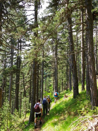
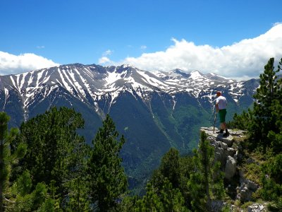
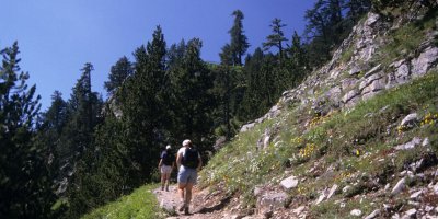
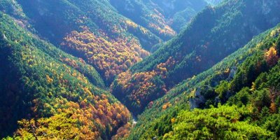
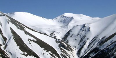
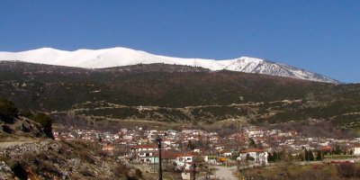
Hiking
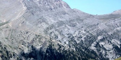
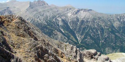
Hiking in Mount Olympus and the Pierian mountains Hiking is the most popular activity for people of all ages. Depending on how fit you are, you can choose between a wide variety of trails on the beautiful mountains on Pieria and enjoy their rare beauty. Read moreCategory: Outdoor
Subcategory: Hiking
Photos:
Distance straight:5.007,93 klm
Direction:SSW
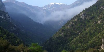
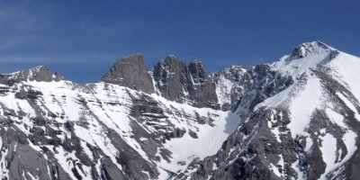
Climbing in Mount Olympus and the Pierian Mountains
Climbing in Mount Olympus and the Pierian mountains to reach the top. Apart from the European trail E4, crossing two mountains, there are many marked trails to climb Mount Olympus, each with a different level of difficulty. To cater for the needs of mountaineers, there are eight shelters on Mount Olympus and six emergency shelters. There are two shelters on the Pierian mountains. To experience the wide variety of the activities, visitors can ask for information from public or private sports centers, sports and climbing clubs and specialized organisations, as well as tourist facilities organizing the activities. Read moreCategory: Outdoor
Subcategory: Climbing
Photos:
Distance straight:5.007,93 klm
Direction:SSW
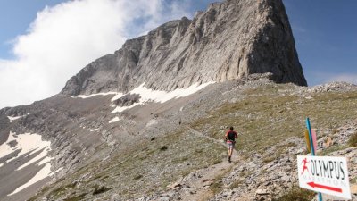
Mountain running
Mountain running in Mount Olympus and the Pierian mountains Mountain running takes place in mountain trails and trails through forests on steep or rocky grounds, hills, forests and valleys that require walking or hiking, high fitness level and suitable equipment. Pieria hosts mountain racing events the most popular of which is the Olympus Marathon sports event with high participation from famous marathon runners from Greece and abroad. To experience the wide variety of the activities, visitors can ask for information from public or private sports centers, sports and climbing clubs and specialized organisations, as well as tourist facilities organizing the activities. Read moreCategory: Outdoor
Subcategory: Hiking, Climbing
Photos:
Distance straight:5.007,93 klm
Direction:SSW
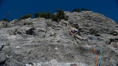
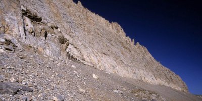
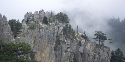
Rock climbing
Climbing with organized climbing routes (Mylos in Litochoro) and the Pierian mountains, mountain guides and two artificial climbing tracks. To experience the wide variety of the activities, visitors can ask for information from public or private sports centers, sports and climbing clubs and specialized organisations, as well as tourist facilities organizing the activities. Read moreCategory: Outdoor
Subcategory:
Photos:
Distance straight:5.007,93 klm
Direction:SSW
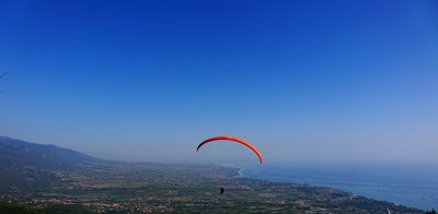
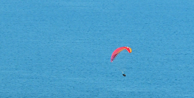
Parachute or Parapente or Paragliding
On Mount Olympus you find one of the largest and most significant take-off areas where fans of parachuting and paragliding can enjoy a spectacular view landing on the coasts of Pieria. To experience the wide variety of the activities, visitors can ask for information from public or private sports centers, sports and climbing clubs and specialized organisations, as well as tourist facilities organizing the activities. Read moreCategory: Outdoor
Subcategory:
Photos:
Distance straight:5.007,93 klm
Direction:SSW
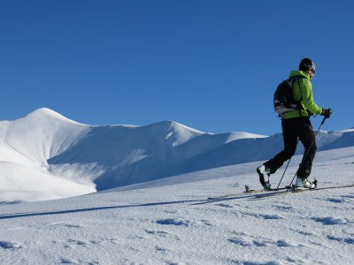
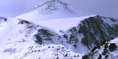
Ski mountaineering
Ski mountaineering on Mount Olympus Ski mountaineering is a lesser-known mountain sports, adored by a few. It has recently been organized as a tourist activity and there are also races and steep freelance routes. To experience the wide variety of the activities, visitors can ask for information from public or private sports centers, sports and climbing clubs and specialized organisations, as well as tourist facilities organizing the activities. Read moreCategory: Outdoor
Subcategory: Climbing
Photos:
Distance straight:5.007,93 klm
Direction:SSW
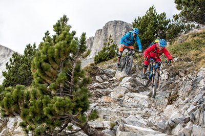
Mountain Biking
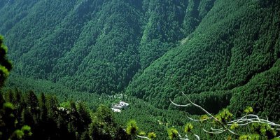
Mountain Biking in Mount Olympus and the Pierian mountains, with countless routes through green trails, forest trails and unexplored areas, ranging in level of difficulty. The routes combine mountain and sea as well as religious and archaeological sites in Pieria. To experience the wide variety of the activities, visitors can ask for information from public or private sports centers, sports and climbing clubs and specialized organisations, as well as tourist facilities organizing the activities. Read moreCategory: Outdoor
Subcategory:
Photos:
Distance straight:5.007,93 klm
Direction:SSW
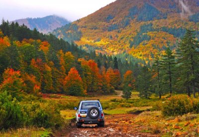
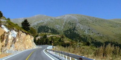
4x4 trails
4x4 routes for those who love driving with intensity, who enjoy a great variety of routes and wish to create unforgettable experiences on the forest roads of Mount Olympus and the Pierian mountains. To experience the wide variety of the activities, visitors can ask for information from public or private sports centers, sports and climbing clubs and specialized organisations, as well as tourist facilities organizing the activities. Read moreCategory: Outdoor
Subcategory:
Photos:
Distance straight:5.007,93 klm
Direction:SSW
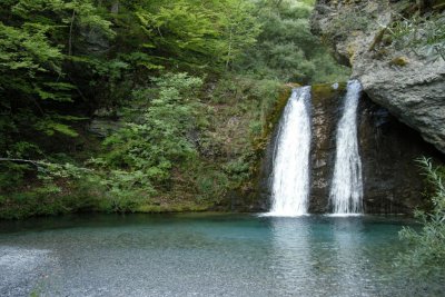
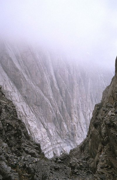
Canyoning and special descending on Mount Olympus
Canyoning and special descending on Mount Olympus in a stunning environment with rich vegetation, crystal clear waters, steep hillsides and marvelous gorges. You will find organized routes with equipment and different levels of difficulty. The fans of canyoning will enjoy the unique opportunities in Olympus, the Enipeas gorges and the Orlia stream. To experience the wide variety of the activities, visitors can ask for information from public or private sports centers, sports and climbing clubs and specialized organisations, as well as tourist facilities organizing the activities. Read moreCategory: Outdoor, Water
Subcategory:
Photos:
Distance straight:5.007,93 klm
Direction:SSW
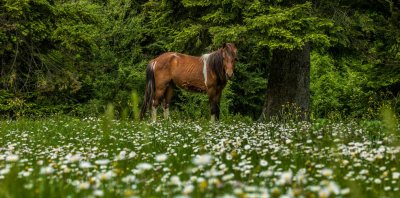
Horse riding
The excursions and horse-riding walks, either individually or in groups, for educational purposes, to work out or experience adventure in the Pierian mountains and locations of great beauty in the woods, create memorable experiences from the world of horses and the Pierian nature. You can experience these moments in horse riding clubs and in specific organized farms-ranches in Pieria. Read moreCategory: Outdoor
Subcategory:
Photos:
Distance straight:5.007,93 klm
Direction:SSW
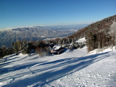
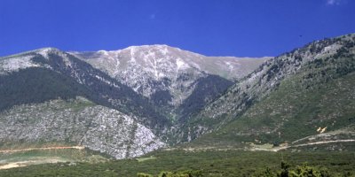
Skiing
Skiing in the organized Ski Resort in Elatochori, located in the northeastern side of the Pierian mountains in the “Papa Chorafi” location, 1450 meters above sea level on a beautiful location with an amazing view of Mount Olympus and Aliakmonas river. The ski resort includes 10 ski slopes of different altitudes and levels of difficulty. There is also a snowboarding slope and one for sleighs. The total length of the slopes and the network of the snow routes connecting them is more than 12.000 meters. The ski resort includes a two-floor chalet, a gift shop, a ski-and-snow equipment rental shop and a Read moreCategory: Outdoor
Subcategory: Climbing
Photos:
Distance straight:5.007,93 klm
Direction:SSW
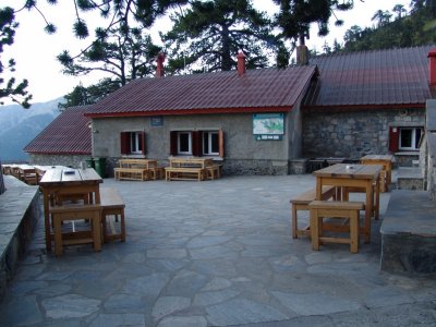
Mount Olympus Shelters
Today there are 8 shelters on Mount Olympus operating to serve the needs of visitors, hikers and climbers. Located in significant locations along the main routes towards the mountain top of Olympus are 6 additional emergency refuges. Refuges “Spilios Agapitos” Refuge Located in an altitude of 2040 meters above sea level on the “Balcony” location of Mount Olympus, the refuge has the capacity to house 110 people and includes a restaurant. Telephone: 23520 81800, 23520 81329, 6973210687, 6973210688 E-mail: info@mountolympus.gr Website: http://www.mountolympus.gr/ “Giosos Apostolidis” Refuge The highest Greek refuge located 2700 above sea level next to the mountain top “Profitis Elias”. The refuge can house 90 people and includes one Read moreCategory: Outdoor
Subcategory: Hiking, Climbing
Photos:
Distance straight:5.007,93 klm
Direction:SSW
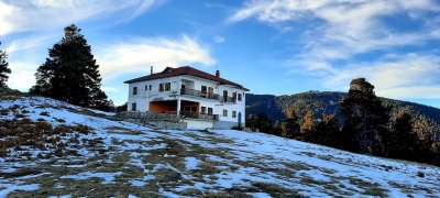
Shelters in the Pierian mountains
The Pierian mountains have two mountain shelters. These mountain shelters are the first step to amazing hiking routes or climbing to known and unknown trails leading to the high Pierian peaks. Sarakatsana Shelter on the Pierian mountains Located in an altitude of 1680 meters above sea level on a small plateau in the Pierian mountains, overlooking the Thermaic Gulf, Mount Olympus, the astonishing pine forest and the Flabouro peak 2200m above sea level, the Sarakatsana shelter can host 80 people and includes a restaurant. Telephone: 6979 842633 E-mail: seokaterini@gmail.com Website: https://www.sarakatsana.com/ Ano Milia Shelter Ano Milia shelter, “Giannis Hasiotis” is located 1100m above sea level on the Pierian mountains. Τelephone: 6977587345 E-mail: info@eoskaterinis.gr Website: https://eoskaterinis.gr/ Read moreCategory: Outdoor
Subcategory: Hiking, Climbing
Photos:
Distance straight:5.007,93 klm
Direction:SSW
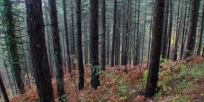
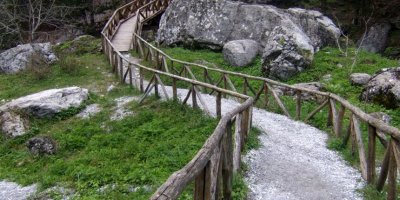
Olympus hiking trail 1, Litochoro – Prionia
From the area “Myli” (400m.), one of the entrances of the National Park, on the upper part of the Litochoro city, begins the international mountain trail E3 crossing the breathtaking Enipeas gorge. The trail is in good condition, equipped with the suitable signs and after many slopes it leads to the location “Prionia”, on the springs of Enipeas (1100m.) The trail follows the Enipeas gorge, on the left side of the riverbed. After crossing half the path, the trails crosses Enipeas 7 times – on beautiful wooden bridges – overlooking the riverbed either from the right or the left side. In Read moreCategory: Outdoor
Subcategory: Hiking
Photos:
Distance straight:5.007,93 klm
Direction:SSW
Olympus hiking trail 2, Prionia – Katafygio – Spilios Agapitos
The route from Prionia (1100m.) up to the “Spilios Agapitos” mountain shelter is the most widely crossed path of Mount Olympus. It is part of the E4 trail and it is part of the route Litochoro – Prionia. Prionia is the last location to be reached by car (lies 18km away from Litochoro) where visitors will find parking space. The springs of the Enipeas river are also found there. A refreshment area and a restaurant are always available in the location Prionia. The largest part in the route crosses the forests. The forest is well maintained. The combination of oak trees and Read moreCategory: Outdoor
Subcategory: Hiking
Photos:
Distance straight:5.007,93 klm
Direction:SSW
Olympus hiking trail 3, Spilios Agapitos – Skala – Mytikas
The route is advancing in difficulty from the location Skala to Mytikas. Beginning from the first mountain shelter “Spilios Agapitos” (2040m.) the path ascends and after 20 minutes it follows the area of “Chondro Mesorachi” up to the intersection “Zonaria” on the right at an altitude of 2480m. A few meters above on the left, it crosses the path to Stavraities and Agios Antonios. Following the main E4 path, on a bare alpine landscape, quite steep, after about an hour climbers reach “Skala” peak at an altitude of 2866m. From that point on, we continue following the red marks on Read moreCategory: Outdoor
Subcategory: Hiking
Photos:
Distance straight:5.007,93 klm
Direction:SSW
Olympus hiking trail 4, Spilios Agapitos – Louki – Mytikas
This route initially begins as the previous one until reaching 2480m above sea level and the path for Zonaria. At this point follow the path to the right which starts off incredibly steep in the beginning before following the undulations of the mountain for some time up to Louki leading to Mytikas. In Louki we observe the typical red arrows painted on the rocks marking the way to Mytikas. This route is quite difficult and the last stretch in "Louki" is somewhat dangerous due to the risk of landslides therefore requiring caution. Route: difficult (with some dangerous sections)Duration (h): 3Difference in elevation: 818Length (m): 2900 Read moreCategory: Outdoor
Subcategory: Hiking
Photos:
Distance straight:5.007,93 klm
Direction:SSW
Olympus hiking trail 5, Spilios Agapitos – Muses Plateau
Ascending from Spilios Agapitos shelter towards the peaks, within the first few minutes of hiking, there is a branch in the path to the right in the direction of Muses Plateau (Plateau of the Muses) (2.650 m) where Giosos Apostolidis & Christos Kakkalos Refuges are located.This path is also known as Kofto (sharp) as it cuts down the total hiking time to Muses Plateau. It is quite steep and in some parts where the snow rarely melts, it requires caution. It passes lower than the Zonaria path. Route: difficultDuration (m): 90Difference in elevation (m): 550Length (m): 3800 Read moreCategory: Outdoor
Subcategory: Hiking
Photos:
Distance straight:5.007,93 klm
Direction:SSW
Olympus hiking trail 6, Gkortsia – Petrostrougka – Muses Plateau
Fourteen km along the Litochoro – Prionia road, a narrow road leads off to a parking area. This location is called Gortsia and from here starts a wide path leading to Muses Plateau and the mountain shelters Christos Kakkalos and Giosos Apostolidis. Two thirds of the route pass through an amazing forest while the rest is through an alpine landscape with low vegetation. Prior to departing, it is essential to stock up on water supplies as there is no spring with a reliable flow of water along the route. There are two springs, one at Strango and another one in the Read moreCategory: Outdoor
Subcategory: Hiking
Photos:
Distance straight:5.007,93 klm
Direction:SSW
Olympus hiking trail 7, Muses Plateau – Korifes
MUSES PLATEAU – LOUKI - MYTIKA (Giosos Apostolidis & C. Kakkalos Refuges) ROUTE ADifficult: Dangerous routeDuration (h): 1Difference in elevation (m): 268Length (m): 1500 Starting out from Muses Plateau and specifically from the refuges of Giosos Apostolidis (2.700 m) and Christos Kakkalos (2.640 m) continue the route towards the high peaks. The path begins from both refuges. Passing the area known as Portes on the right, continue along the path passing beneath Stefani and arriving at the saddle between the two peaks, look to the left and in front at Mytikas and to the right at Stefani. Follow the red arrows painted on the rocks which lead Read moreCategory: Outdoor
Subcategory: Hiking
Photos:
Distance straight:5.007,93 klm
Direction:SSW
Olympus hiking trail 8, Litochoro – Gkolana – Kastanas Spring
On the road from Litochoro to Agios Ioannis we find a crossroad leading to Agios Ioannis on the left and Profitis Ilias on the right. An uphill path begins from these crossroads which leads to the area of Golna in about an hour. From this location there is an impressive view of the high peaks of Mount Olympus and Enipea Gorge. The path continues descending in a northwest direction and after some time intersects with the E4 path connectingLitochoro and Prionia. Take this path east heading towards Litochoro. This is a relatively easy route and offers a brief taste of Olympus as Read moreCategory: Outdoor
Subcategory: Hiking
Photos:
Distance straight:5.007,93 klm
Direction:SSW
Olympus hiking trail 9, Prionia – Agio Spilaio – Holy Monastery of Saint Dionysius
This route makes up the final section of route No 1 and essentially makes an easy circle around the area connectingthe sights around the old monastery (Palaia Moni). After arriving at Prionia by car, head down the E4 path to Litochoro. Before arriving at Agios Dionysios Monastery, we come across clearings and a small hut. Turn right and follow the path which soon takes you to the Enipea waterfall. Returning to the E4 cross the Enipea River over a wooden bridge and continue along the path for another 20 minutes towards Agio Spilaio where tradition has it Saint Dionysios lived as Read moreCategory: Outdoor
Subcategory: Hiking
Photos:
Distance straight:5.007,93 klm
Direction:SSW
Olympus hiking trail 10, Agia Triada in Vrontou – Krevatia – Barbalas
On the road from Vrontou village towards Agia Kori after about 4 km, there is a crossroad with a turning to the right with an asphalt road which makes a steep descent towards Agia Triada and Palaia Vrontou. Taking this turning after a few minutes there is a sign for Agia Triada and shortly after that the stone churchyard of Agia Triada church appears (400 m). It should be noted that there are no water springs on this route. After the altitude measure of 770 m on the right in the forest is a path that leads to Karoutia spring with Read moreCategory: Outdoor
Subcategory: Hiking
Photos:
Distance straight:5.007,93 klm
Direction:SSW
Olympus hiking trail 11, Krevatia in Vrontou – Papa Aloni – Agia Triada
This route has a good deal of ascents and descents and due to the low altitude, it is highly suitable for the winter season too. The route begins from the Krevatia Vrontous Refuge (1005m) and from here there is an old path which descends towards Agia Triada Stream flowing right below the Barbalas peak and after about an hour hike arrives at the Agia Triada Stream. It is a wonderful route with a view of the high peaks and the canyon. It is a relatively easy hike and crosses a stunning forest accompanied by the relaxing sound of flowing waters, though Read moreCategory: Outdoor
Subcategory: Hiking
Photos:
Distance straight:5.007,93 klm
Direction:SSW
Olympus hiking trail 12, Agios Konstantinos – Koromilia – Petrostrouga
A less known route of rare beauty begins at Agios Konstantinos and Agia Eleni chapel 4 km along the forested road from Dion to Koromilia. Immediately after the chapel on the turn in the road is the start of the path which has recently been signposted and runs parallel to Orlia Stream. If the forested road is not in a good passable condition, the same point can be reached by taking the asphalt road from Karitsa village to Agios Vasileios chapel where the car can be parked. From here take the main path for approximately 1 hour after which you will see a Read moreCategory: Outdoor
Subcategory: Hiking
Photos:
Distance straight:5.007,93 klm
Direction:SSW
Olympus hiking trail 13, Agia Kori – Mastorouli – Kleftovresi
Four km along the road from Vrontou to Agia Kori having passed the crossroads for Agia Triada and Palaia Vrontou there is a forested road (13.5 km) on the right which leads to Arapi Stream. Begin the route essentially keeping to the road for approximately 1 hour and 30 minutes without stops and keeping Agia Kori Stream on the left until the point where the road descends prior to crossing the stream. There is a path which reaches this point and crosses the road many times and it is worth following it in order to shorten the route. On the right Read moreCategory: Outdoor
Subcategory: Hiking
Photos:
Distance straight:5.007,93 klm
Direction:SSW
Olympus hiking trail 14, Kokkinopilos – Megali Gourna – Skala
The E4 path passes the edge of the village (1100 m) beginning in a southern direction and after Stalamatias stream, it continues to the east. Cross the beautiful Stalamatias Gorge following the line of the river and coming out on the alpine plateau which meets the forested road leading to Megali Gourna which is home to Emergency Refuge (2.550 m). From here head up towards Skolio peak (2.911 m) and diverting to the right follow the ridge which leads to Skala (2.866 m) This route is the natural continuation of the E4 path between Litochoro and Skala going in the opposite direction. Route: Read moreCategory: Outdoor
Subcategory: Hiking
Photos:
Distance straight:5.007,93 klm
Direction:SSW
Olympus hiking trail 15, Kokkinopilos – Kitros – Kserolaki
This is one of the lesser known, but incredibly beautiful routes that Mount Olympus has to offer. Setting out from Kokkinopilos (1.100 m) in the direction of Roudi spring (1.800 m) the route passes through a thick forest. On arriving at the clearing with the spring, which it should be noted does not supply water all year round, ascend to the ridge line which connects the peaks of Anthimos (1.198 m) and Kitros (2.416 m). The view from Kitros peak is absolutely stunning. From here follow the ridge line from Kitros (2.416 m) – Nana (2.284 m) – Steni Salatoura (2.089 Read moreCategory: Outdoor
Subcategory: Hiking
Photos:
Distance straight:5.007,93 klm
Direction:SSW
Olympus hiking trail 16, Kserolaki – Naoum stream – Muses Plateau
Five km along the forested road between Petra and Kokkinopilos there is a road on the left which is closed off with a bar. This area is called Bara. Take this road and continue for a further 10 km and it arrives at Naoum Stream. The road cuts the stream across and crosses beneath the small caves. Leave the car here and continue on foot taking the path which follows the line of the stream. It is a stunning route through the wild natural beauty and provides an unusual view of the high peaks. After crossing the stream the route arrives at Read moreCategory: Outdoor
Subcategory: Hiking
Photos:
Distance straight:5.007,93 klm
Direction:SSW
Olympus hiking trail 17, Kserolakki – Megali Gourna
Follow the forested road from the previous route (No 17) and approximately 2 km after Naoum Stream the road passes through the Xerolakki Stream (1.350 m) where there is a cement water tank. Immediately parallel to the stream a road ascends which leads up higher in the stream (1.600 m). Follow the path of the stream until Megali Gourna valley (2.550 m) which is home to the stone built emergency refuge (at certain times of the year the entire refuge is covered in snow and cannot be considered an option for an overnight stay or shelter from the weather). The route starts Read moreCategory: Outdoor
Subcategory: Hiking
Photos:
Distance straight:5.007,93 klm
Direction:SSW
Olympus hiking trail 18, Kserolakki – Vresi Karaiskini – Papa Rachi – Muses Plateau
This is a difficult route and many sections are unmarked. On the forested road of the previous two routes (No 17-18) 8km after the crossroads for Bara (or two km before reaching Naoum Stream), there is a road on the left. Here the road meets a stream and immediately after the turn in the stream, park the car and take the footpath on the left of the road. After a few minutes hike, the path opens onto a large clearing known as Patralexi. Cross the clearing heading in the direction of Papa Rachi keeping Karaiskini Stream to the right. On re-entering the Read moreCategory: Outdoor
Subcategory: Hiking
Photos:
Distance straight:5.007,93 klm
Direction:SSW
Olympus hiking trail 19, Karya – Diaselo Metamorfosis/Kakavrakou – Skolio – Mytikas
From the village the O2 path (which begins in Crete and intersects with the international alpine path the E4 which leads from the Pyrenees to Mytikas) leads to Harvalovrysi and then on to the south alpine slope between the peaks of Kakavrako and Metamorfosi. From Diaselo it is possible to head for Bara and Agios Antonios or through the O2 path to “Stavroities” and Skala, Skolio and Mytikas. Follow this path until reaching a rocky sharp edge on your left. At this point, turn left to a narrow, ascending and unclear path that crosses the feet of this sharp edge on Read moreCategory: Outdoor
Subcategory: Hiking
Photos:
Distance straight:5.007,93 klm
Direction:SSW
Olympus hiking trail 20, Vrysopoules – Skolio
In Larissa Prefecture after Sparmos village on the way to Kryovrysi there is a road which begins and heads through the forest for 17 km ending in the area called Vrysopoules. This is the location of the Military Alpine Combat and Ski Training Centre. Refuge «Vrysopoules KEOAX» is located right above the military base at an altitude of 1.805 m. A path starts here and initially directly follows the pylons of the ski centre until it reaches the emergency Refuge (2.450 m) and continues on the left side of Agios Antonios peak ending at the saddle between the peaks of Agios Read moreCategory: Outdoor
Subcategory: Hiking
Photos:
Distance straight:5.007,93 klm
Direction:SSW
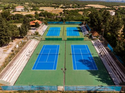
Other sports and activities in Pieria
Apart from the sports outlined in the previous sections, visitors in the Regional Unit of Pieria have the opportunity to participate in a variety of other sports such as soccer (in a field, 5x5, beach soccer), basketball, volleyball, beach volleyball, tennis, swimming and water polo. Visitors can also enjoy cycling, motocross, go-kart, air and water sports, chess, ping-pong, pool, mini-golf, paintball, etc. At specified times permitted by the competent authorities and according to the set rules to protect the fauna of Pieria, visitors can also partake in hunting and fishing. Visitors can participate in other sports such as track, handball, gymnastics, shooting, archery, Read moreCategory: Outdoor, Sea, Water
Subcategory: Climbing, Hiking
Photos:
Distance straight:5.007,93 klm
Direction:SSW