Sights(39 Results)
Filters
Show on map

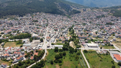
History of Municipality of Levadia
It is characteristic that the Municipality of Levadia boundaries include eight important ancient cities such as Levadia, Cheronia, Koronia, Davlida, Alalkomenai, Panopeas, Flygonion and Voulida. The rich history of the region is due to the important geographical location of the cities, which was crucial for their development. They were built on the road that connected the important commercial and religious centers and many other large and powerful cities of ancient Greece. This contributed to the development and often the destruction of the region by barbarian raids. Major and critical battles in the area had a significant impact on ancient history and are Read moreCategory: Monument, Religious
Subcategory: Archaeological, Historically, Ethnological
Photos:
Distance straight:0,37 klm
Direction:NE
The city of Levadia
The area of Levadia has been continuously inhabited since the Proto-Hellenic period until today. According to Homer (8th BC legendary author of the famous epic poems Iliad and Odyssey), it participated in the Trojan War under the name "Midia". Later it was renamed Levadia by the Athenian settler Levados, who settled the inhabitants in the current location of the city. Levadia was associated with the Oracle of Trophonius, the chthonic local deity, whose fame gradually transformed Levadia into a famous religious centre and holy city of the Boeotians. Here are the springs of Lithi and Mnimosini and the Sacred Grove. Read moreCategory: General interest
Subcategory: General interest
Photos:
Distance straight:0,37 klm
Direction:NE

The Oracle of Trophonius
Ancient Levadia was associated with the Oracle of Trophonius, the chthonian local deity that operated probably from the 6th century BC in the wider area of Kria. The fame of the Oracle with the awe and mysticism it exuded, gradually established Levadeia as a renowned religious centre and holy city of the Boeotians. At the springs of Kria, Lithi and Mnimosini, in what is considered the area of the Oracle, the Sacred Grove is developed. The religious needs of the operation of the Oracle and the development of the worship of Zeus Vasileos from the 4th century BC, gradually transformed the Read moreCategory: Monument
Subcategory: Archaeological, Historically, Landscape
Photos:
Distance straight:0,59 klm
Direction:S

The Medieval Castle of Livadia
The Medieval Castle of the city dominates the Boeotian capital. In order to protect it from barbarian raids, the construction of the Castle began, probably during the Early Byzantine period in the 4th - 5th century on top of other older and smaller fortifications. Building material from the ancient buildings of the Sacred Grove was used for the construction and is visible in the lower layers of the foundations. The activity of the city was limited to the safety of the fortification of the Castle after the destruction and desolation brought by the barbarian raids until the Middle Byzantine period of Read moreCategory: Monument
Subcategory: Archaeological, Historically, Castles, Church/Chapels, Tower, Landscape, Canyon, Religious
Photos:
Distance straight:0,66 klm
Direction:SW

The Trichino stone bridge
The Trichino Bridge is located southwest of the medieval castle and connects the banks of the Xiria stream that crosses the gorge of Krya. Its construction dates back to the early Ottoman period during the 15th century. The bridge consists of a central thin arch and two arched spans (the western one is Islamic, pointed type). Waterworks were found that ensured the supply of water to the castle. The aqueduct bridge connects the two sides of the gorge and a water channel passes over it. A network of clay pipes, supported by retaining walls, ensured the necessary inclination for the steady Read moreCategory: Monument, Outdoor
Subcategory: Archaeological, Canyon, Historically, Landscape
Photos:
Distance straight:1,00 klm
Direction:SW

The Temple of Zeus Vasileos (King)
The glory of the Oracle of Trophonius and the construction of a colossal temple for the worship of Zeus Vasileos (King), the first temple of the god with this surname, justifies the religious influence of Levadeia as a Holy City and its great fame in the known world of that time. The ruins of the imposing-sized Temple of Zeus Vasileos are located on what may be the western edge of the Sacred Grove of Trophonius on the hill of Prophitis Ellias. Construction began in the 3rd century BC and was finally discontinued in the 2nd century BC, probably due to the Read moreCategory: Monument, Outdoor
Subcategory: Archaeological, Historically
Photos:
Distance straight:2,00 klm
Direction:SW

The river Erkyna and the area of Krya
The beautiful river with the feminine name "Erkina", which crosses Livadia, is a natural monument around which the whole city has lived and breathed since ancient times. Its name comes from the Nymph of the river Erkina and daughter of Trophonius. Its banks are dominated by centuries-old plane trees, watermills and waterfalls and a hint of the ancient glory of the region full of myths and stories. It originates from Krya, from the ancient springs of Lithi and Mnemosini and flows into the Boeotian Kifissos. Krya is a natural park, a place for recreation, relaxation and walking, as well as a Read moreCategory: Nature
Subcategory: Historically, Archaeological, Castles, Landscape, Tower
Photos:
Distance straight:0,60 klm
Direction:S

The Krias Gorge
The gorge of Krya starts after the tourist pavilion “Xenia” next to the bed of the stream Xiria where we find the stone theater with 1,200 seats, where the cultural events of the Municipality take place. A climbing park with several marked routes has been created on the steep rocks of the gorge. Moving on and reaching the plateau, two options open up before the visitor, one is to up the 700 stone steps to get high up the steep side of the gorge to the chapel of Agios Minas and Jerusalem and the other, walking through the gorge to reach the Read moreCategory: Nature, Outdoor
Subcategory: Canyon, Natural History, Landscape
Photos:
Distance straight:0,62 klm
Direction:S

Small chapel of Agia Jerusalem
On a particularly steep slope of the gorge of Kria, after the chapel of Agios Minas, in the cave of Zoodochos Pigi, is the small chapel of Agia Jerusalem. The church inside has a small well with water that locals believe brings good luck. The visitor who climbs the approximately 700 steps will be compensated by the stunning view. Across to the left we can see the Medieval castle, in the background Mount Parnassos, to the right the stone theater, below the gorge formed by the Xirias stream and in the background the city of Livadeia and the plain of Kopaida. In Read moreCategory:
Subcategory:
Photos:
Distance straight:0,98 klm
Direction:SSW

The Tower of Time
The Tower of Time dominates the area and is a symbol for the city of Livadeia. The original building seems to have been built during the Frankish period (1204-1311 BC) on the remains of more ancient constructions. It was lower than the present building and because of its prominent position it was used as a beacon tower. In 1803 during the Turkish occupation when Lord Elgin arrived in Livadeia, he donated a clock to the town in order to influence the locals and the authorities in the hope that they would allow him to carry out excavations for the Oracle of Read moreCategory: Monument
Subcategory: General interest
Photos:
Distance straight:0,24 klm
Direction:SW

Mosque of Gazi Omer Bey or Mosque of the Bazaar
The Gazi Omer Bey Mosque or the Mosque of the Bazaar is located in the historic center of the city, at the intersection of General Ioannou and Tsoga streets. It dates back to the second half of the 15th century AD. Omer Bey conquered Livadeia in 1460 AD and therefore he was given the title of Gazi. The word is Arabic and means fighter. As a devoted Muslim he built a mosque, which was to be the center of Islamic life in the region for three and a half centuries. There were three Ottoman mosques on today`s Stratigou Ioannou Street that Read moreCategory: Monument
Subcategory: Mosque
Photos:
Distance straight:0,18 klm
Direction:SW

Museum of Old Professions
In the Museum of Old Professions, the visitor has the opportunity to discover old professions that contributed to the economic and professional history of the country and have been lost. Objects, photographs, machines and tools of professions such as the water seller, the ice seller, the milkman, the itinerant grocer, the lamplighter, the farrier, the grinder, the shoemaker, etc. are exhibited. The Museum of Old Professions was created on the initiative of the Commercial Association of Livadeia and is housed in its offices in a magnificent neoclassical building in the historic center of the city. Read moreCategory: Museum
Subcategory: Ethnological
Photos:
Distance straight:0,15 klm
Direction:SW

Ano Sourpi
Ano Sourpi is "the balcony of Mount Helicon". It is an old village that has been almost abandoned. The residents moved lower down to the mountain outskirts and created the village of Analipsi (formerly Sourpi). It is located at an altitude of 830 m in the natural reserve of Latsoudi, below the peak of Koliedes. The view of the plain of Kopaida, Mount Parnassos and often of Evia island is exceptional. The chapel of Agios Georgios is preserved in the area. In the surrounded of the chapel the visitor can relax and cool off from the fountains with cold water from Read moreCategory: Nature
Subcategory: General interest, Mountain, Landscape
Photos:
Distance straight:6,00 klm
Direction:SW

Traditional Village of Elikonas
The traditional Village of Elikonas, formerly known as Zeriki, is the highest village of the mountain range of Mount Helicon, built at an altitude of 850 m. on a small plateau probably in the 14th century by Arvanites. The area is considered to be of natural beauty. The plateau is cultivated and produces excellent quality pulses, except in winter when water accumulates, creating a small lake that often freezes. The whole area is surrounded by dense spruce forest. A short distance from the village is the organised camping center of Paliomilia. Read moreCategory: Nature
Subcategory: Lakes, Traditional Settlement, Landscape
Photos:
Distance straight:9,00 klm
Direction:SW

Elikonas Museum of Agricultural Heritage
In the Traditional Village of Elikonas operates the Museum of Agricultural Heritage. It hosts a number of exhibits of folk tradition, articles of daily use, a small library and the collection of Mr. Mitsos and Mr. Skourletis. The Association of Elikonians of the Livadeia district, which is responsible for the operation of the Museum, has developed an educational program for primary, secondary and high school children, to introduce them to the cycle of bread, from the grain to the table. Children are introduced to the different stages of wheat cultivation and learn in an experiential way the traditional bread production process, Read moreCategory: Museum
Subcategory: Theme, Folklore, Library, Traditional Settlement
Photos:
Distance straight:8,00 klm
Direction:SW

Ancient Cheronia
Cheronia is located in the plain of the Boeotian Kifissos. The present village is built on the site of ancient Cheronia. Archaeological findings and reports confirm that the area was inhabited from the 6th millennium BC. The ancient acropolis of Cheronia crowns the hill of Petrachos with parts of the fortification of the Archaic period, a cyclopean construction of Mycenaean origin and later parts of the 4th century BC. The fortification seems to have surrounded the surviving theater, which is dated from the end of the 5th century BC. The famous battle of Cheronia took place in the area in 338 Read moreCategory: Outdoor, Monument
Subcategory: Settlement, General interest, Historically, Castles
Photos:
Distance straight:7,00 klm
Direction:NW

The Lion of Cheronia
The "Lion of Cheronia" is the most recognizable historical symbol of Boeotia. Created by the Thebans and guards a polyandrium where the fallen men of the Sacred Band were buried after the victory of the Macedonians of Philippos in 338 BC in the important battle of Cheronia. Excavations at the site have revealed the skeletons of 254 men and part of their weaponry. In 1904, expert archaeologists led by the sculptor Lazaros Sochos assembled the pieces, filled in the missing pieces with stones from the Xiria stream of Livadeia that matched the colour and restored the monument. The monument is 5,5 Read moreCategory: Monument
Subcategory: Archaeological, Historically
Photos:
Distance straight:7,00 klm
Direction:NW

The Ancient Theater Of Cheronia
On the outskirts of the Petrachos hill below the Acropolis and near the Archaeological Museum is the Ancient Theater of Cheronia. Its first construction dates back to the end of the 5th century BC. It is perfectly integrated into the site, since it was carved into the natural rock of the elevation and could accommodate about 500 spectators.Only the carved into the rock part of the theater is preserved. During the Roman period, several works were carried out which increased the capacity of the theater and slightly modified its appearance. At the entrance to the archaeological site there is a stone-built fountain, Read moreCategory: Monument
Subcategory: Archaeological, Historically
Photos:
Distance straight:7,00 klm
Direction:NW

Archaeological Museum of Chaeronia
The Archaeological Museum of Cheronia is located next to the Lion monument. It has three exhibition areas with archaeological finds from prehistoric to early Christian times, such as important works of pottery, parts of Mycenaean frescoes, coins and weapons from the tomb of the Macedonians and the polyandrium of the Thebans, burial objects from necropolises, sculptures from Livadeia and Cheronia. Important exhibits include prehistoric objects of everyday use from the Neolithic Age and a collection of bronze vessels from the area of Orchomenos. Very important is also the replica of a house of the Neolithic period. In the hall of the Read moreCategory: Museum
Subcategory: Archaeological
Photos:
Distance straight:0,46 klm
Direction:NW

The Ancient Acropolis of Chaeronea
The ancient acropolis of Cheronia crowns the elevation of Petrachos, where today ruins of the walls of the Classical and Mycenaean period and foundations of temples, architectural elements and epigraphs are preserved. The increased defensive needs of Cheronia made necessary the fortification of the Petrachos elevation, which has a height of 150 m and two peaks. The position of the acropolis is ideal and ensured the supervision over the entire plain of the Boeotian Kifissos. Already from prehistoric times there are cyclopean fortifications construction. A small cave located in the acropolis is considered to be the concentration point of the ancient Cheronian Read moreCategory:
Subcategory:
Photos:
Distance straight:7,00 klm
Direction:NW

Ragavi Tower
Κοντά και πίσω από στο Αρχαιολογικό Μουσείο της Χαιρώνειας ξεχωρίζει ένα πυργόσχημο κτήριο. Ανήκε στη μεγάλη οικογένεια των Ποστέλνικων (Υπουργών Εξωτερικών της Βλαχίας, αρχαιολόγων, ποιητών σοφών και συγγραφέων), των Ραγκαβή. Χτίστηκε σε κτήματα που της παραχωρήθηκαν από το ελληνικό κράτος μετά την απελευθέρωση ως ένδειξη ευγνωμοσύνης για τη συνεισφορά στον αγώνα για την απελευθέρωση από τους Τούρκους. Read moreCategory: Monument
Subcategory: Tower, Historically
Photos:
Distance straight:7,00 klm
Direction:NW

The Acropolis of Panopeas
The ancient acropolis of Panopeas dominates the hill above the settlement of Agios Vlasios. Of the entire ancient Mycenaean period fortification that surrounded the acropolis, only some parts of the wall and some towers survive. Homer (ancient legendary author of the epic poems of Iliad and Odyssey) mentions in the Iliad that the builder of the notorious Trojan Horse was the Epeus, son of Panopeas. The acropolis of Panopeas was first inhabited in the 18th century BC, and during the Mycenaean period it was fortified with cyclopean walls. The city was refortified with strong walls shortly before the great battle of Read moreCategory: Monument
Subcategory: Archaeological
Photos:
Distance straight:10,00 klm
Direction:NW

Davlia
Ηistory of Davlia dates back to prehistoric times and retains a constant presence until today. According to Strabo (1st BC century Greek geographer, philosopher and historian), its name comes from the dense forests (in ancient Greek "davla") of the region and according to Pausanias (2nd AD Greek traveler and geographer) from the nymph Davlida. Ancient Davlida was built on the southeastern side of Mount Parnassos, near the road leading from Cheronia to Delphi, the famous "Schisti Odos" which started from Delphi and was divided into two directions, one towards Thebes and the second towards Davlida. According to Greek mythology, Oedipus met Read moreCategory:
Subcategory:
Photos:
Distance straight:15,00 klm
Direction:NW

The castle and the acropolis of ancient Davlida
On the verdant hill opposite Davlia, dominates the Castle and the acropolis of ancient Davlida. It is an ancient cyclopean fortress with a long history of use and panoramic view of Mount Parnassos and the plain of the Boeotian Kifissos. In the area of the acropolis, ruins of the fortification from the 4th century BC are preserved. The base of the fortification wall is older and dates back to prehistoric times. The shape of the wall is circular and the only entrance on the north-western side was protected by two towers. The main entrance to the acropolis is called Sideroporta Read moreCategory: Monument
Subcategory: Archaeological
Photos:
Distance straight:15,00 klm
Direction:NW

Kiriaki
Kiriaki is a mountain village built on the western slopes of Mount Helicon in a green and beautiful landscape at an altitude of 780 meters. Opposite the village on the hill Paliokastro there are the ruins of the ancient city Fligonion. Its inhabitants are Arvanites who settled the area in the 14th century and named the settlement Kiriaki from the chief shepherd Kyriakos. A short walk around the village will reveal its secrets to the visitor. The Great Cold Fountain, which was once the only source of water supply, the stone chapel of Panagia, which was the first church of the Read moreCategory: General interest
Subcategory:
Photos:
Distance straight:12,00 klm
Direction:SW

The Teacher`s Museum
The Teacher`s Museum is a special museum with exhibits donated by the teacher Mr. Nikolaos Gkonias. It is part of his personal archive, a rich collection of educational material from the second half of the 20th century. The collection is considered to be of great educational, aesthetic and historical value. Read moreCategory: Museum
Subcategory: Theme
Photos:
Distance straight:12,00 klm
Direction:SW

The Laographic Μuseum of Kiriaki
The Laographic Μuseum of the village exhibits traditional objects of everyday use of the residents from the past. Read moreCategory: Museum
Subcategory: Folklore
Photos:
Distance straight:12,00 klm
Direction:SW

The ancient city Fligonion
Το Φλυγόνιον ήταν αρχαία πόλη στην κορυφή του λόφου Παλιόκαστρο, απέναντι από το χωριό Κυριάκι. Ο επισκέπτης μπορεί να διακρίνει ερείπια της αρχαίας πόλης που σώζονται μέχρι σήμερα. Συστηματικές ανασκαφές δεν έχουν γίνει και ό,τι γνωρίζουμε είναι από αναφορές του Παυσανία. Το Φλυγόνιον ήταν μία από τις πόλεις που κατέστρεψε ο Περσικός στρατός του Ξέρξη στο πέρασμά του από την Φωκίδα. Η πόλη καταστράφηκε, το 346 π.Χ. από τον στρατό του Φιλίππου του Μακεδόνα. Στην κορυφή του λόφου βρίσκεται ένα μικρό εξωκλήσι αφιερωμένο στον Άγιο Νεκτάριο. Από εκεί, μπορεί κανείς να θαυμάσει την υπέροχη θέα της περιοχής, του Κορινθιακού κόλπου και Read moreCategory:
Subcategory: Archaeological, Historically, Church/Chapels
Photos:
Distance straight:12,00 klm
Direction:SW

Arvanitsa
Arvanitsa is a forest recreation area on Mount Helicon, between Kiriaki and Agia Anna in a very green landscape. It is an area of particular natural beauty, organized, ideal for excursions, walks, sports activities and climbing. The rich flora of the area offers unique moments of relaxation in a virgin forest of fir, cedar, pine and wildflowers. During the summer, a three-day music festival is organized that attracts thousands of visitors from all over Greece. Visitors have the opportunity to enjoy various types of music from renowned Greek artists and camp in the forest. Read moreCategory: Nature
Subcategory: Mountain
Photos:
Distance straight:13,00 klm
Direction:S

Koronia
Koronia is a mountain village built on the verdant slopes of Mount Helicon. Homer (8th BC ancient legendary author of the epic poems of Iliad and Odyssey) mentions its participation in the Trojan War. According to tradition, it was founded by the foster son of Athamantas, Koroneos. The great fame of ancient Koronia was due to the great festival of the Boeotians, the Pamboiotia, which was held in the famous temple of goddess Athena Itonia, the patron saint of the city, during which all hostilities in the region were stopped. Today in the area there are ruins of the polygonal walls Read moreCategory:
Subcategory: General interest
Photos:
Distance straight:11,00 klm
Direction:SE

Cave of the Nymph
"Den of Libithridon Nymphs" according to Strabo (1st BC century Greek geographer, philosopher and historian) or the "Sanctuary of Libithridon Muses” according Pausanias (2nd AD Greek traveler and geographer), is located between Koronia and Agia Triada, on the north-eastern slopes of Mount Helicon, at an altitude of about 820 meters. Its interior consists of a hall of 8Χ10 meters. At the entrance of the cave there is the epigraph "Koronia Nymph". The findings include vases, micro-sculptures and various offerings. The cave is not an organised archaeological site. A selection of findings is exhibited in the Archaeological Museum of Thebes. A small Read moreCategory: Monument
Subcategory: Archaeological, Cave
Photos:
Distance straight:9,00 klm
Direction:S

Kefalovriso
Just outside Koronia is the developed recreation area Kefalovriso. It is a green area full of plane trees and fountains at the sources of the ancient river Koralios. Read moreCategory:
Subcategory:
Photos:
Distance straight:12,00 klm
Direction:SE

Chapel of the Taxiarches
Before we reach the village of Agia Triada (formerly Steveniko), next to the springs of Pontza, is the former monastery and current chapel of Taxiarchis, which dates back to the post-Byzantine period. The interior is adorned with magnificent hagiographies dated around 1825 and many inscribed stones and plaques. It is built mainly of stones with votive inscriptions from the sanctuary of Charopas Heraclis. In the nearby area in antiquity there were also ancient temples of the Nymphs and Charites, the Goddess Demeter and Roman summer palaces. In the autumn they celebrated the rapture of Persephone by Pluto. In the summer Read moreCategory: Religious, Nature, Monument
Subcategory: Church/Chapels, Archaeological
Photos:
Distance straight:7,00 klm
Direction:SE

Agios Georgios
Agios Georgios is a small town built at the foot of Mount Helicon southeast of Livadeia. It was developed at the end of the 18th century when residents of Livadeia settled in the area due to a plague epidemic that had broken out in the Boeotian town. The residents are mainly engaged in agriculture. The Music School of Livadeia is also located here. Read moreCategory: General interest
Subcategory:
Photos:
Distance straight:7,00 klm
Direction:SE

Agia Triada
Agia Triada (formerly Steveniko) is a beautiful mountain village built at the foot of Mount Helicon at an altitude of 400 meters. The existence of Roman epigraphs and a Byzantine castle reinforces the view that the area was inhabited in antiquity or in the Medieval period. The settlement is first mentioned in Ottoman documents of 1466 AD under the name of Steveniko and is recorded as a Greek-speaking settlement, in contradiction to the neighbouring villages, which are referred to as Arvanitic villages. During the late Turkish occupation it was the largest settlement in its region and was a point of Read moreCategory:
Subcategory: General interest
Photos:
Distance straight:0,00 klm
Direction:

Agia Anna
Agia Anna (former Koukoura) is a beautiful mountain village in the fir trees at an altitude of 720 meters. The village is surrounded by fir and oak forests. In the area very small lakes are formed by the large concentration of water in the winter season. Visitors have the opportunity to tour the forest, climb to the top of Mount Helicon and taste traditional dishes in the taverns of the area. Read moreCategory: General interest
Subcategory: Mountain
Photos:
Distance straight:14,00 klm
Direction:SSE

Alalkomenes
The ancient city was built, according to tradition, by the hero Alalkomenes. It was located between the cities of Aliarto and Koronia, southwest of Lake Copaida. It was known from the sanctuary of Alalkomenio, which was dedicated to goddes Athena. According to the tradition of the region, the great goddess had been born there and for this reason it was considered as a sacred city. Today in the place of the ancient Alalkomenes there is a small settlement with the same name. The railway station of Alalkomenes was inaugurated in 1904 and was built by the "English Company of Lake Copaida" Read moreCategory:
Subcategory:
Photos:
Distance straight:10,00 klm
Direction:

Ancient Voulida
Ancient Voulida was a city near the bay of Zaltsa. Systematic excavations have not been done and what we know is from reports of Pausanias (2nd AD Greek traveler and geographer) who visited it. The ruins of Voulida are visible to the visitor, with carved scales in stone and parts of the fortification. The residents were mainly fishermen and produced porphyra dye from shells. It was destroyed by Philip of Macedonia in 346 BC. It is reported that there were two wooden statues of the goddess Artemis and Dionysus and they honored the god Megistos, probably Zeus. Access is relatively Read moreCategory:
Subcategory:
Photos:
Distance straight:18,00 klm
Direction:SSW

Nearby visits
The visit to Livadeia can be combined with excursions and activities in the nearby areas such as Arachova, the ski resort of Parnassos, Delphi, the Monastery of Osios Loukas, the Monastery of Evangelistria, the waterfalls of Petra, the gardens of Aliartos, the air club of Kopaida, the Treasure of Minyas and the springs of Charites in Orchomenos, the river Boeotikos Kifissos, the mining park of Fokida, the museum of Thebes, etc. Read moreCategory: General interest
Subcategory:
Photos:
Distance straight:0,00 klm
Direction: